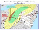
The WVGES has prepared an Excel spreadsheet containing the API numbers of 1,700 West Virginia wells for which we have scanned e-logs which penetrated the top of the Onondaga Limestone (and therefore penetrate the base of the overlying Devonian shales). However, (see Schwietering’s maps above) an unconformity exists between the younger Rhinestreet black shale and the Onondaga Limestone in portions of Cabell, Mason, McDowell, Mingo, and Wayne counties; the Marcellus and other Hamilton Group shales are missing in these areas.
The spreadsheet of scanned e-logs which penetrate the top of the Onondaga Limestone can be downloaded here Top_of_Onondaga_Penetrations_with_scanned_elogs.xls.
The individual scanned TIFF images for these logs are available for free downloading at http://downloads.wvgs.wvnet.edu/welllogs/; the associated well data are available on our online “pipeline” data application at http://www.wvgs.wvnet.edu/oginfo/pipeline/pipeline2.asp.
Further Information: For questions about Devonian shales (including the Marcellus Shale), please contact Katharine Lee Avary, WVGES, avary@geosrv.wvnet.edu.
From